Kerala
18 декабря 2022 04:45
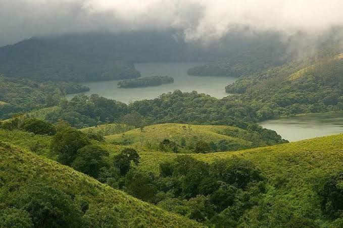
The Nilgiri Biosphere Reserve is a biosphere reserve in the Nilgiri mountains of the Western Ghats in South India. It is the largest protected forest area in India, spreading across Tamil Nadu, Karnataka and Kerala. It includes the protected areas Mudumalai National Park, Mukurthi National Park, Sathyamangalam Wildlife Sanctuary in Tamil Nadu; Nagarhole National Park, Bandipur National Park, both in Karnataka; Silent Valley National Park, Aralam Wildlife Sanctuary, Wayanad Wildlife Sanctuary, and Karimpuzha Wildlife Sanctuary in Kerela. An ecosystem of the hill ranges of Nilgiris and its surrounding environments covering a tract of over 5000 square kilometers was constituted as Nilgiris Biosphere Reserve by UNESCO in September 1986 under Man and Biosphere Programme. Nilgiris Biosphere Reserve is India's first and foremost biosphere reserve with a heritage, rich in flora and fauna. Tribal groups like the Badagas, Toda, Kotas, Irulla, Kurumba, Paniya, Adiyan, Edanadan Chettis, Allar, Malayan are native to the reserve. India's natural Gold fields are also located in the regions in and around Nilgiris Biosphere Reserve scattered in the states of Karnataka, Kerala, and Tamil Nadu.
━━━━━━━━━━━━━
🏝 @ | @ 🥥
Читать полностью…
Kerala
16 декабря 2022 02:59
The KDHP Tea Museum is an industry and history museum situated in Munnar, a town in the Idukki district of Kerala in South India. Tata Tea Museum is its official name, but it's also known as Nalluthanni Estate where it is located, or Kannan Devan Hills Plantation (KDHP) Tea Museum. The tea Museum was established by Tata Tea in 2005 at Nallathanni estate. The museum chronicles the journey of the growth of tea in Munnar. The museum has many photographs and machines celebrating the legacy of the plantations owners and workers who ensured the survival of tea plantations here for long.The transition from the rudimentary tea roller to the modern fully-automated tea factory is an interesting sight to watch. So is the process of tea making. The demonstration room here attracts most tourists. Some of the most exotic teas in the world are available here. The tea Museum will be a delightful experience for tea lovers.
━━━━━━━━━━━━━
🏝 @ | @ 🥥
Читать полностью…
Kerala
14 декабря 2022 04:04
Thrippunithura or Tripunithura, is a prominent historical and residential region in the City of Kochi in Kerala, India. Located about 7 km (4 mi) from the city centre, Tripunithura was the capital of the erstwhile Kingdom of Cochin. The descendants of the Cochin royal family still live in the palaces here. The Hill Palace situated in Tripunithura was the palace of Maharaja of Cochin, the ruler of Kingdom of Cochin. Tripunithura is also well known for its historical cultures and worldwide famous because of Sree Poornathrayeesa Temple and the annual festival Vrishchikoltsawam that takes place at the temple.
━━━━━━━━━━━━━
🏝 @ | @ 🥥
Читать полностью…
Kerala
12 декабря 2022 02:30
Thenmala is a tourist destination in the eastern side of Kollam district in Kerala, India that is home to the first eco-tourism centre in India. The word 'Thenmala' means "'Honey hills" in the Malayalam language. The town is 66 km away from Kollam city and is just 14 km away from the Tamil Nadu state border. The interstate National Highway-744, connecting Kollam with Madurai in Tamil Nadu, and State Highway-2 of Kerala are passing through Thenmala.
━━━━━━━━━━━━━
🏝 @ | @ 🥥
Читать полностью…
Kerala
10 декабря 2022 03:30
The Southern Naval Command is one of the three command-level formations of the Indian Navy. It has its headquarters in Kochi, Kerala at INS Venduruthy. It is the Training Command of the Indian Navy.
The Command is commanded by a Three Star Flag Officer of the rank of Vice Admiral with the title Flag Officer Commanding-in-Chief Southern Command (FOC-in-C). Vice Admiral M. A. Hampiholi, AVSM, NM is the current FOC-in-C SNC, who took over on 30 November 2021.
━━━━━━━━━━━━━
🏝 @ | @ 🥥
Читать полностью…
Kerala
08 декабря 2022 05:43
The Anamala or Anaimalai, also known as the Elephant Mountains, are a range of mountains in the southern Western Ghats of central Kerala (Idukki district, Ernakulam district, Palakkad district, Thrissur district) and span the border of western Tamil Nadu (Coimbatore district and Tiruppur district) in Southern India. The name anamala is derived from the Malayalam word aana and the Tamil word aanai, meaning elephant, or from tribal languages. Mala or Malai means 'hill', and thus 'Elephant hill'.
━━━━━━━━━━━━━
🏝 @ | @ 🥥
Читать полностью…
Kerala
06 декабря 2022 03:15
Alappuzha railway station (also known as Alleppey railway station, code: ALLP) is located at Alappuzha, Kerala, India. The station is a major station on the Ernakulam–Kayamkulam coastline. It is an NSG 3 category station. The station is operated by the Southern Railway zone of the Indian Railways and comes under the Thiruvananthapuram railway division.
━━━━━━━━━━━━━
🏝 @ | @ 🥥
Читать полностью…
Kerala
04 декабря 2022 06:26
The Malabar Coast is the southwestern coast of the Indian subcontinent. Geographically, it comprises the wettest regions of southern India, as the Western Ghats intercept the moisture-laden monsoon rains, especially on their westward-facing mountain slopes. The term is used to refer to the entire Indian coast from the western coast of Konkan to the tip of India at Kanyakumari. The peak of Anamudi, which is also the point of highest altitude in India outside the Himalayas, and Kuttanad, which is the point of least elevation in India, lies on the Malabar Coast. Kuttanad, also known as The Rice Bowl of Kerala, has the lowest altitude in India, and is also one of the few places in the world where cultivation takes place below sea level.
━━━━━━━━━━━━━
🏝 @ | @ 🥥
Читать полностью…
Kerala
02 декабря 2022 01:22
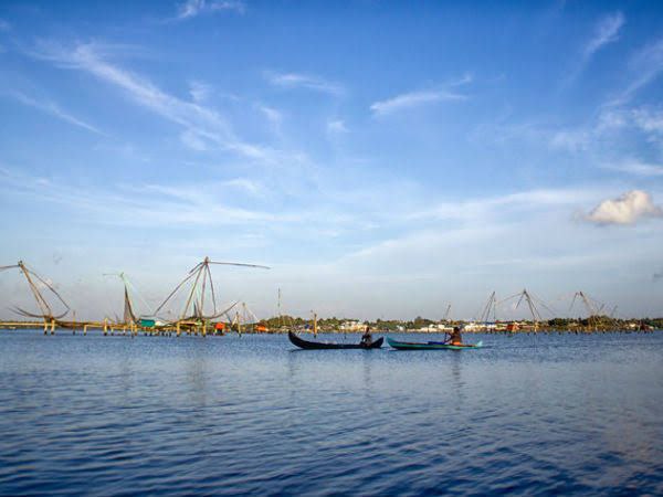
The Kerala backwaters are a network of brackish lagoons and canals lying parallel to the Arabian Sea of the Malabar coast of Kerala state in south-western India. It also includes interconnected lakes, rivers, and inlets, a labyrinthine system formed by more than 900 km (560 mi) of waterways, and sometimes compared to bayous. The network includes five large lakes linked by canals, both man made and natural, fed by 38 rivers, and extending virtually half the length of Kerala state. The backwaters were formed by the action of waves and shore currents creating low barrier islands across the mouths of the many rivers flowing down from the Western Ghats range. In the midst of this landscape there are a number of towns and cities, which serve as the starting and end points of backwater cruises. There are 34 backwaters in Kerala. Out of it, 27 are located either closer to the Arabian Sea or parallel to the sea. The remaining 7 are inland navigation routes.
━━━━━━━━━━━━━
🏝 @ | @ 🥥
Читать полностью…
Kerala
30 ноября 2022 02:22
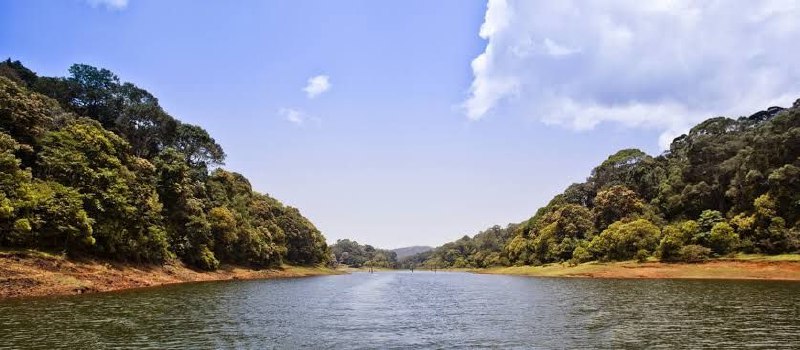
Kundala Dam is a dam built in Kundala, Madupetty Panchayat in Idukki district of Kerala, India, as part of the Pallivasal Hydroelectric Project on the Muthirapuzha River, a tributary of the Periyar River. It is also called Setuparvatipuram Dam. This dam was completed in 1947. This is a masonry arch dam having a height of 46.93 metres (154.0 ft). Length is 259.38 metres (851.0 ft). Release from dam is to river Palar and taluks through which release flow are Udumpanchola, Devikulam, Kothamangalam, Muvattupuzha, Kunnathunadu, Aluva, Kodungalloor and Paravur. The Kundala dam was constructed for Pallivasal Hydro Electric Project in 1946 and is considered to be Asia’s first arch dam.
━━━━━━━━━━━━━
🏝 @ | @ 🥥
Читать полностью…
Kerala
28 ноября 2022 03:15
Cherai Beach is a beach located in Cherai in the northern side of Vypin Island, a suburb of the city of Kochi in the state of Kerala, India. One of the most visited beaches in the state, it is situated at around 25 km (15 mi) from downtown Kochi and 20 km (12 mi) from Cochin International Airport.
━━━━━━━━━━━━━
🏝 @ | @ 🥥
Читать полностью…
Kerala
26 ноября 2022 02:02
Thekkady (Idukki district) is a town near Periyar National Park, an important tourist attraction in the Kerala state of India. The name Thekkady is derived from the word "thekku" which means teak. Temperatures are lowest in the months of December–January and highest in the months of April–May. Thekkady is situated about 257 km (160 mi) from Trivandrum, 145 km from Cochin International Airport and 114 km from Kottayam railway station, and is located 4 km away from Kumily, a plantation town in Kerala-Tamil Nadu border.
━━━━━━━━━━━━━
🏝 @ | @ 🥥
Читать полностью…
Kerala
24 ноября 2022 06:52
Nilambur is a major town, a municipality and a Taluk in the Malappuram district of the Indian state of Kerala. It is located close to the Nilgiris range of the Western Ghats on the banks of the Chaliyar River. This place is also known as 'Teak Town' because of the abundance of Nilambur teaks in this area; Which is a variety of a large, deciduous tree that occurs in mixed hardwood forests. Unlike many Municipalities of India; Nilambur is covered with large amounts of vegetation making it close to nature and hence make it very scenic and inspiring.
━━━━━━━━━━━━━
🏝 @ | @ 🥥
Читать полностью…
Kerala
22 ноября 2022 06:06
Kozhikode, also known in English as Calicut, is a city along the Malabar Coast in the state of Kerala in India. It has a corporation limit population of 609,224 and a metropolitan population of more than 2 million, making it the second largest metropolitan area in Kerala and the 19th largest in India. Kozhikode is classified as a Tier 2 city by the Government of India. It is the largest city in the region known as the Malabar and was the capital of the British-era Malabar district. In antiquity and the medieval period, Kozhikode was dubbed the City of Spices for its role as the major trading point for Indian spices. It was the capital of an independent kingdom ruled by the Samoothiris (Zamorins). The port at Kozhikode acted as the gateway to the medieval South Indian coast for the Chinese, the Persians, the Arabs and finally the Europeans. According to data compiled by economics research firm Indicus Analytics in 2009 on residences, earnings and investments, Kozhikode was ranked the second best city in India to live in.
━━━━━━━━━━━━━
🏝 @ | @ 🥥
Читать полностью…
Kerala
20 ноября 2022 06:06
Munroe Island or Mundrothuruthu is an inland island group located at the confluence of Ashtamudi Lake and the Kallada River, in Kollam district, Kerala, South India. It is a group of eight small islets comprising a total area of about 13.4 km². The island, accessible by road, rail and inland water navigation, is about 25 kilometres (16 mi) from Kollam by road, 38 kilometres (24 mi) north from Paravur, 12 kilometres (7.5 mi) west from Kundara and about 25 kilometres (16 mi) from Karunagapally. As of the 2011 Indian census, the administrative village of Mundrothuruth (which includes nearby small villages as well) has a total population of 9599, consisting of 4636 males and 4963 females. This island is also known as "Sinking Island of Kerala". The place is named in honour of Resident Colonel John Munro of the former Princely State of Travancore. The islands measure 13.4 square kilometres (5.2 sq mi) in area.
━━━━━━━━━━━━━
🏝 @ | @ 🥥
Читать полностью…
Kerala
17 декабря 2022 03:10
Chandragiri Fort is a fort built in the 17th century, situated in Kasaragod District of Kerala, South India. This large squarish fort is 150 feet (46 m) above sea level and occupies an area of about seven acres adjacent to Chandragiri river. The fort is now in ruins. The fort is located around 59 km south of Mangalore and 87 km north of Kannur at the mouth of the Chandragiri river.
━━━━━━━━━━━━━
🏝 @ | @ 🥥
Читать полностью…
Kerala
15 декабря 2022 02:54
The Meenachil River or Meenachilaar, also known as Kavanar, Valanjar, is a river in Kerala. It is one of the most treacherous rivers in Kerala due to its flash floods, heavy undercurrents and woods and debris it carries from the mountains. It flows through the heart of Kottayam district, Kerala state in southern India. 78 km long, originates in the Western Ghats main tributaries are Theekoy aaru from Vagamon hills, Poonjar Aaru and Chittar, flowing westward through the city of Kottayam and other towns like Poonjar, Teekoy, Erattupetta, Bharananganam, Pala, Mutholy, Cherpunkal, Kidangoor and Kumarakom before emptying into the Vembanad Lake on the shore of the Indian Ocean.
━━━━━━━━━━━━━
🏝 @ | @ 🥥
Читать полностью…
Kerala
13 декабря 2022 02:27
Vallarpadam is one among the group of islands, that form part of Kochi, in the state of Kerala, India. It is situated in the Vembanad Lake, locally known as The Kochi Lake and has a population of over 10,000. Vallarpadam is one of the two islands, the other being Willingdon Island, around which the Port of Kochi is situated. The International Container Transshipment Terminal of the port is situated entirely in Vallarpadam island. Vypin island lies on its west side and Mulavukad island lies to its east.
━━━━━━━━━━━━━
🏝 @ | @ 🥥
Читать полностью…
Kerala
11 декабря 2022 04:51
Panoor is a Municipality in the district of Kannur in the state of Kerala, India. The town is the main market place for the farmer communities in the surrounding regions. Panoor is one of the main suburbs of the City of Thalassery. Panoor got municipal status when the Government of Kerala decided to upgrade Panoor Grama Panchayat and added with other Panchayats, as Panoor Municipality in 2015.
━━━━━━━━━━━━━
🏝 @ | @ 🥥
Читать полностью…
Kerala
09 декабря 2022 01:50
Willingdon Island is the largest artificial island in India, which forms part of the city of Kochi, in the state of Kerala. Much of the present Willingdon Island was claimed from the Lake of Kochi, filling in dredged soil around a previously existing, but tiny, natural island. Willingdon Island is significant as the home for the Port of Kochi as well as the Kochi Naval Base, the Southern Naval Command of the Indian Navy, Plant Quarantine station, Custom House Cochin and Central Institute of Fisheries Technology, a constituent unit of Indian Council of Agricultural Research.
The island is also home for other establishments associated with the port, namely, the Office of the Cochin Port Trust (that controls the Port of Kochi), the Customs Office, and more than two dozen export-import offices, warehouses, a few hotels and business centers.
━━━━━━━━━━━━━
🏝 @ | @ 🥥
Читать полностью…
Kerala
07 декабря 2022 03:27
Kavvayi Backwaters located near Payyanur is the third largest backwater in Kerala and the largest one in north Kerala. The Kavvayi Kayal (backwaters) is dotted with several small and large islands. Valiyaparamba island is the largest among them and stretches over 16 km².
━━━━━━━━━━━━━
🏝 @ | @ 🥥
Читать полностью…
Kerala
05 декабря 2022 05:51
Kappil is a tourist spot in Kollam district, Kerala state, India. It is located in Edava Panchayat of Paravoor at the coast of the Arabian Sea. It is 18 km (11 mi) north of Kollam city centre. Paravoor Railway Station is a major railway station near Kappil.
━━━━━━━━━━━━━
🏝 @ | @ 🥥
Читать полностью…
Kerala
03 декабря 2022 03:26
Thiruvathira or Thiruvathirai or Arudhra Darisanam is a Hindu festival celebrated in the Indian states of Kerala and Tamil Nadu. Thiruvathirai (Arudhra) in Tamil means "sacred big wave". In Chidambaram in Tamil Nadu, the Sri Natarajar temple's annual Festival, is celebrated on this date. In the month of Makaram Thiruvathira Star is celebrated in Mathira Peedika Devi Temple, owned by Thiruvithamcore Devaswom Board, near Kadakkal in Kollam District of Kerala state. Thiruvathira has a connection with lord moon.
━━━━━━━━━━━━━
🏝 @ | @ 🥥
Читать полностью…
Kerala
01 декабря 2022 02:31
Vembanad is the longest lake in India, as well as the largest lake in the state of Kerala. With an area of 230 square kilometers and a maximum length of 96.5 km. Spanning several districts in the state of Kerala, it is known as Vembanadu Lake in Kottayam, Vaikom, Changanassery, Punnamada Lake in Alappuzha, Punnappra, Kuttanadu and Kochi Lake in Kochi. Several groups of small islands including Vypin, Mulavukad, Maradu, Udayamperoor, Vallarpadam, Willingdon Island are located in the Kochi Lake portion. Kochi Port is built around the Willingdon Island and the Vallarpadam island.
━━━━━━━━━━━━━
🏝 @ | @ 🥥
Читать полностью…
Kerala
29 ноября 2022 03:31
Cochin International is an International airport serving the city of Kochi, in the state of Kerala, India. Located at Nedumbassery, about 25 kilometres (16 mi) northeast of the city centre, Cochin International Airport is the first of its kind which is developed under a public-private partnership (PPP) model in India. This project was funded by nearly 10,000 non-resident Indians from 32 countries. It is the busiest and largest airport in the state of Kerala and 4th biggest airport in South India. As of 2019, the Cochin International Airport caters to 61.8% of the total air passenger movement in Kerala. It is the third busiest airport in India in terms of international traffic and also ninth busiest overall. In fiscal year 2018–19, the airport handled more than 10.2 million passengers with a total of 71,871 aircraft movements.
━━━━━━━━━━━━━
🏝 @ | @ 🥥
Читать полностью…
Kerala
27 ноября 2022 04:32
Kizhunna beach is one of the most popular beach destinations located around 11 km from Kannur, Kerala. It is a secluded beach which is frequented by those who value solitude. The gentle wind and warm sands make for a delightful blend to simply have a stroll or a sunbath in the middle of the day.
━━━━━━━━━━━━━
🏝 @ | @ 🥥
Читать полностью…
Kerala
25 ноября 2022 05:02
Vagamon is an Indian hill station and a revenue village primarily located in Peerumedu taluk of Idukki district (majority area including Vagamon town), and also Meenachil taluk and Kanjirappally taluk of Kottayam district in the state of Kerala, India.
━━━━━━━━━━━━━
🏝 @ | @ 🥥
Читать полностью…
Kerala
23 ноября 2022 04:21
Peermade, also spelt Peerumade (Malayalam: പീരുമേട്) is a village, Grama Panchayat and hill station in the state of Kerala, India. It lies 915 metres (3,002 ft) above sea level in the Western Ghats (Sahyadri) about 85 kilometres (53 mi) east of Kottayam on the way to Thekkady through the nearby city of Kanjirappally.
━━━━━━━━━━━━━
🏝 @ | @ 🥥
Читать полностью…
Kerala
21 ноября 2022 03:10
Sivagiri is an area in Varkala municipality of Trivandrum District in Kerala. It is a pilgrimage centre of Varkala Town where the tomb, or samadhi, of Sree Narayana Guru is situated. It is a place where Guru built the Sarada Temple dedicated to Sarada Devi. The tomb is an attraction for thousands of devotees every year, especially during the Sivagiri Pilgrimage days (Sivagiri Theerthadanam) from 30 December to 1 January.
━━━━━━━━━━━━━
🏝 @ | @ 🥥
Читать полностью…
Kerala
19 ноября 2022 03:45
Varkala is a major coastal municipality situated in the northern suburb of Trivandrum, capital city of the Indian state of Kerala. It is the headquarters of Varkala Taluk and important government institutions such as the taluk office, court complex, office of the Deputy Superintendent of Police, Legal Metrology Inspector office, Excise Circle and Range office, RTO, Treasury and Mini civil station are situated in here. It is one among the oldest municipalities of Kerala established in 1980.
Varkala is the only region in southern Kerala where cliffs are found adjacent to the Arabian Sea. These Cenozoic sedimentary formation cliffs are a unique geological feature on the otherwise flat Kerala coast, and are known among geologists as Varkala Formation. The cliffs have been declared a national geological monument by the Geological Survey of India for their protection, maintenance, promotion, and the enhancement of geotourism. There are numerous water spouts and spas on the sides of these cliffs. In 2015, the Ministry of Mines, the Government of India, and the Geological Survey of India (GSI) declared Varkala Cliffs a geo-heritage site.
━━━━━━━━━━━━━
🏝 @ | @ 🥥
Читать полностью…


 10192
10192