Kerala
17 июля 2023 06:17
Pathanamthitta is a municipality situated in the Central Travancore region in the state of Kerala, India, spread over an area of 23.50 km². It is the administrative capital of Pathanamthitta district. The town has a population of 37,538. The Hindu pilgrim centre Sabarimala is situated in the Pathanamthitta district; as the main transport hub to Sabarimala, the town is known as the 'Pilgrim Capital of Kerala'. Pathanamthitta District, the thirteenth revenue district of the State of Kerala, was formed with effect from 1 November 1982, with headquarters at Pathanamthitta. Forest covers more than half of the total area of the District. Pathanamthitta District ranks the 7th in area in the State. The district has its borders with Allepey, Kottayam, Kollam and Idukki districts of Kerala and Tamil Nadu. Nearest City Is Thiruvalla, located At A Distance Of 30 km. Thiruvalla Railway Station Is 30 km via Thiruvalla-Kumbazha Highway. Buses Ply Every 4 Minutes From Thiruvalla To Pathanamthitta & vice versa.
━━━━━━━━━━━━━
🏝 @ | @ 🥥
Читать полностью…
Kerala
15 июля 2023 08:14
Angamaly is a town located just above north Kochi city in Kerala, India. It is part of the Kochi metropolitan area and is best known for its agricultural industry.
It is situated about 30 km (19 mi) north of the city centre, the town lies at the intersection of Main Central Road (MC Road) and National Highway 544.MC Road. Angamaly at its intersection with NH 544. Cochin International Airport is less than 10KM away from the town of Angamaly.
Originally established as a panchayat in May 1952, Angamaly became a municipality in April 1978 and is also a Legislative Assembly constituency from 1965 in the Ernakulam district.
━━━━━━━━━━━━━
🏝 @ | @ 🥥
Читать полностью…
Kerala
13 июля 2023 06:47
Muvattupuzha is a town, municipality in the midlands directly to the east of Kochi in Ernakulam district, Kerala, India. It is located about 36 km (22 mi) from downtown Kochi, and is a growing urban centre in central Kerala. The town is also the starting point of the Muvattupuzhayar (Muvattupuzha river), which is a confluence formed by three rivers: the Thodupuzhayar, Kaliyar, and Kothayar.
Muvattupuzha is bordered by the Kottayam district on the southern side and the Idukki district on the eastern side. Muvattupuzha lies on the intersection between MC Road and National Highway 49, about 28 km (17 mi) from the district capital Ernakulam. Muvattupuzha is located 20 km (12 mi) from Thodupuzha, 17 km (11 mi) from Koothattukulam, and 5 km (3.1 mi) away from Arakuzha. It is the second biggest commercial center of the district and one of the biggest in the central part of the state. There are two major malls: Canton Mall & Grand Central Mall.
━━━━━━━━━━━━━
🏝 @ | @ 🥥
Читать полностью…
Kerala
11 июля 2023 06:09
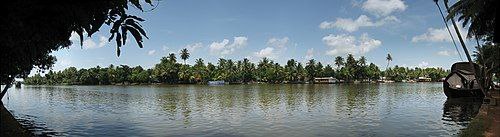
The Pamba River (also called Pampa River) is the longest river in the Indian state of Kerala after Periyar and Bharathappuzha, and the longest river in the erstwhile former princely state of Travancore.
The river is also known as Dakshina Bhageerathi. During ancient times, it was called 'River Baris' and jordan of malankara. The River Pamba enriches the lands of Pathanamthitta district and the Kuttanad area of Alappuzha district and few areas of Kottayam.
━━━━━━━━━━━━━
🏝 @ | @ 🥥
Читать полностью…
Kerala
09 июля 2023 09:55
Alappad is a coastal village in the Kollam district of the Indian state Kerala. It is situated on a narrow strip of land sandwiched between the Arabian Sea and the TS Canal – the village is approximately 16 km long and its narrowest point is as thin as 33 meters. Connect to the mainland is by bridge as well as by country boat ferries, operated by the Panchayat and private parties. Until recently there was only one bridge at the southern point of the land strip, but after the 2004 tsunami, two other bridges have been constructed. The protests are taking place in the village against Unscientific sand mining by IREL.
━━━━━━━━━━━━━
🏝 @ | @ 🥥
Читать полностью…
Kerala
07 июля 2023 07:37
Munroe Island or Mundrothuruthu is an inland island group located at the confluence of Ashtamudi Lake and the Kallada River, in Kollam district, Kerala, South India. It is a group of eight small islets comprising a total area of about 13.4 km². The island, accessible by road, rail and inland water navigation, is about 25 kilometres (16 mi) from Kollam by road, 38 kilometres (24 mi) north from Paravur, 12 kilometres (7.5 mi) west from Kundara and about 25 kilometres (16 mi) from Karunagapally. As of the 2011 Indian census, the administrative village of Mundrothuruth (which includes nearby small villages as well) has a total population of 9599, consisting of 4636 males and 4963 females. This island is also known as "Sinking Island of Kerala".
━━━━━━━━━━━━━
🏝 @ | @ 🥥
Читать полностью…
Kerala
05 июля 2023 05:58
Paravur Kayal is a lake in Paravur, Kollam district, Kerala, India. Although it is small, with an area of only 6.62 km², it is the end point of the Ithikkara River and part of the system of lakes and canals that make up the Kerala Backwaters. It has been connected to Edava and Ashtamudi Kayal as part of the Trivandrum - Shoranur canal system since the late 19th century.
━━━━━━━━━━━━━
🏝 @ | @ 🥥
Читать полностью…
Kerala
03 июля 2023 18:28
💬 Join @ if you are looking to chat with fellow Indians in Hindi/English/Hinglish. 💭
Читать полностью…
Kerala
02 июля 2023 06:29
Chathannoor is a town in the Indian state of Kerala situated at the Kollam District on the banks of the Ithikkara River. It is about 16 km (9.9 mi) from Kollam(Quilon) City. Chathannoor is around 55 km (34 mi) north of the state capital Thiruvananthapuram (Trivandrum). Chathannoor is a Special Grade Panchayath and is one of the fastest developing towns in Kerala. Shri Diju is the current president of Chathannoor Grama Panchayat.
━━━━━━━━━━━━━
🏝 @ | @ 🥥
Читать полностью…
Kerala
30 июня 2023 07:02
Mahatma Gandhi Road, popularly known as M. G. Road, is the main artery as well as the commercial high street of the city of Kochi, in the state of Kerala, India. The road lies north-south with its boundaries at the Venduruthy bridge, Thevara in the south, and the Madhava Pharmacy Junction in the north, where it intersects the Banerji Road. The road was earlier part of the NH 47A (Old Highway) and was later handed over to Kochi Municipal Corporation. The highway was earlier known as Seventy Feet road. The total distance of the road is 4.5 kilometres (2.8 mi).
━━━━━━━━━━━━━
🏝 @ | @ 🥥
Читать полностью…
Kerala
28 июня 2023 05:57
Vaduthala is a locality in the city of Kochi, India. It is between Pachalam and Chittoor on Chittoor Road. Elamakkara lies towards its east and Mulavukad island on its west. A zonal office of the Corporation of Cochin operates there. Several educational institutions such as Chinmaya Vidyalaya, Don Bosco School, SBOA Public School and Archbishop Attipetty Public School operate there. The nearest hospital is Lourdes Hospital.
━━━━━━━━━━━━━
🏝 @ | @ 🥥
Читать полностью…
Kerala
26 июня 2023 15:35
💬 Join @ if you are looking to chat with fellow Indians in Hindi/English/Hinglish. 💭
Читать полностью…
Kerala
25 июня 2023 06:17
Conolly Canal, sometimes spelled as Canoly Canal, is the part of the West coast canal (WCC) network of Kerala and the canal was constructed by combining the rivers and streams along the coast with the intention of creating a vast waterway from Kozhikode to Kochi. It was constructed in the year 1848 under the orders of the then collector of Malabar, H.V. Conolly, initially to facilitate movement of goods to Kallayi Port from the hinter lands of Malabar through Kuttiyadi and Korapuzha river systems.
━━━━━━━━━━━━━
🏝 @ | @ 🥥
Читать полностью…
Kerala
23 июня 2023 07:19
Olavanna is a census town in Kozhikode district in the Indian state of Kerala. Olavanna is the most populous panchayat in kerala. It is located 10 km from Kozhikode City. Olavanna panchayath shares the border with Kozhikode corporation and Perumanna panchayath. At first it was a large agricultural area. Today there are many small and large scale industries. There are also small marketplaces such as the Pantheerankavu, Olavanna Chungam, Kodinattumukku, Mathara, Palazhi, Kunnathupalam, Iringallor. The railway station is around 10 kilometres away and the nearest airport is Calicut international Airport.
━━━━━━━━━━━━━
🏝 @ | @ 🥥
Читать полностью…
Kerala
21 июня 2023 07:14
Talapady is a village near Mangaluru city in Ullal taluk of Dakshina Kannada district of Karnataka state in India. Talapady borders the states of Karnataka and Kerala. National Highway 66 (earlier numbered as NH-17) passes through Talapady which is 14 km (9 mi) south of Mangalore city. The Karnataka-Kerala checkpost border is situated at Talapady. Another village is Thalapady, Kasargod which is situated near Talapady in Manjeswar crossing Kerala border.
━━━━━━━━━━━━━
🏝 @ | @ 🥥
Читать полностью…
Kerala
16 июля 2023 08:12
Pandalam is a municipal town in Pathanamthitta district Kerala, India. Pandalam is known for its connection with Ayyappan and Sabarimala. Rightly recognised to be the educational and cultural capital of Central Travancore, Pandalam hosts educational institutions ranging from reputed schools to post graduate, training, Ayurveda, and engineering colleges. There are seven colleges and 23 schools at Pandalam, including N. S. S. College, Pandalam. The Kerala state government plans to make the place a special Township, by including the Pandalam municipality and Kulanada panchayat.
━━━━━━━━━━━━━
🏝 @ | @ 🥥
Читать полностью…
Kerala
14 июля 2023 07:52
Perumbavoor is a place located at the bank of Periyar (Poorna River) in Ernakulam District in the Indian state of Kerala. It is a part of the Kochi metropolitan area. It lies in the northeastern tip of the Greater Cochin area and is also the headquarters of Kunnathunad Taluk. Perumbavoor is famed in the state for wood industries and small-scale industries. Ernakulam lies 30 km southwest of Perumbavoor. The town lies between Angamaly and Muvattupuzha on the Main Central Road (MC), which connects Thiruvananthapuram to Angamaly through the old Travancore part of Kerala.
━━━━━━━━━━━━━
🏝 @ | @ 🥥
Читать полностью…
Kerala
12 июля 2023 08:30
Thottappally Spillway is Kuttanad's drain-way out to the Arabian Sea. The Thottappally Spillway splits the Thottappally lake with the fresh water part to the east and saline Thottappally river mouth to the west merging with the Arabian Sea. Thottappally spillway is constructed to spill excess water coming over the Upper Kuttanad and Lower Kuttanad regions through Manimala River, Achancovil River and Pamba River. It is designed such that it could spill off 19,500 cubic meters of water per second, but after its construction it was found that it is able to spill 600 cubic meters of water per second. Reasons for this reduced flow rate are, strong sea breezes during rainy seasons resulting in a rise in sea level relative to the water level of Kuttanad, formation of sand bars on the western area of the spillway and the width of the leading canal is too narrow to carry this much water to the spillway.
━━━━━━━━━━━━━
🏝 @ | @ 🥥
Читать полностью…
Kerala
10 июля 2023 10:03
Kuzhithura is a village in the Kollam district of the Indian state of Kerala. Kuzhithura is part of Alappad panchayat, which is part of the Karunagappally Taluk, situated on a narrow strip of land sandwiched between the Arabian Sea and the Thiruvananthapuram–Shoranur canal. It is a tourist destination with green land, backwaters, and beaches.
━━━━━━━━━━━━━
🏝 @ | @ 🥥
Читать полностью…
Kerala
08 июля 2023 07:48
Karunagappally is a municipality in the Kollam district of Kerala, India. It is 24 km north of Kollam and 60 km (37 mi) south of Alappuzha. Karunagappally taluk consists of Alappad, Ochira, Adinad, Karunagappally, Thazhava, Pavumba, Thodiyoor, Kallalibhagom, Thevalakkara, Chavara, Neendakara, Clappana, Kulasekharapuram, Thekkumbhagam, Ayanivelikulangara, Panmana, Ponmana and Vadakumthala. The taluk is bound on the north by Kayamkulam, on the east by Kunnathur taluk, on the south by Kollam and on the west by the Arabian Sea. It is one of the fastest developing towns in Kerala and is part of Kollam metropolitan area.
━━━━━━━━━━━━━
🏝 @ | @ 🥥
Читать полностью…
Kerala
06 июля 2023 10:14
Ashtamudi Lake (Ashtamudi Kayal), in the Kollam District of the Indian state of Kerala. It possesses a unique wetland ecosystem and a large palm-shaped (also described as octopus-shaped) water body, second only in size to the Vembanad estuary ecosystem of the state. Ashtamudi means 'eight braids' (Ashta : 'eight'; mudi : 'hair braids') in the local Malayalam language. The name is indicative of the lake's topography with its multiple branches. The lake is also called the gateway to the backwaters of Kerala and is well known for its houseboat and backwater resorts. Ashtamudi Wetland was included in the list of wetlands of international importance, as defined by the Ramsar Convention for the conservation and sustainable utilization of wetlands.
━━━━━━━━━━━━━
🏝 @ | @ 🥥
Читать полностью…
Kerala
04 июля 2023 08:25
Paravur is a town and a municipality in the Kollam Metropolitan Area of Kollam district in the Indian state of Kerala. Paravur railway station is the last station in Kollam district which is on the route to Trivandrum while travelling towards South India.
━━━━━━━━━━━━━
🏝 @ | @ 🥥
Читать полностью…
Kerala
03 июля 2023 09:06
Ithikkara River is a 56 km long river in Kerala, India. It originates in the Kulathupuzha in the Western Ghats and flows through the Kollam district, finally emptying into Paravur Lake. The village of Ithikkara is located on the river, 15 km from the port of Kollam. The river also flows through the settlements of Chathannoor and Pooyappally.
━━━━━━━━━━━━━
🏝 @ | @ 🥥
Читать полностью…
Kerala
01 июля 2023 05:38
Vanchiyoor is a locality in downtown Thiruvananthapuram city, the capital of the India state of Kerala. Vanchiyoor occupies an important place in the history of Travancore. It was the district headquarters and most important offices were situated here. There are a lot of heritage monuments in the area. Major administrative, commercial, government and judicial establishments are still located in Vanchiyoor. It is part of Vanchiyoor Village, which holds the prominent administrative headquarters and landmarks of Kerala. Proximity with major educational institutions, offices and shopping centres coupled with easy road connectivity with all parts of the city make it a favoured residential locale in Thiruvananthapuram. Vanchiyoor is 2 kilometres (1.2 mi) from Statue Junction, about 3 kilometres (1.9 mi) from Palayam and 2 kilometres (1.2 mi) from the central railway and bus stations. Trivandrum International Airport lies 6 kilometres (3.7 mi) to the southwest of Vanchiyoor.
━━━━━━━━━━━━━
🏝 @ | @ 🥥
Читать полностью…
Kerala
29 июня 2023 06:32
Chittoor Road is one of the major arterial road in the city of Kochi, India. It is the oldest arterial road in the Ernakulam mainland city that connects Ernakulam south with Chittoor, Kochi island in Ernakulam north. The road runs in North-south direction parallel to coast, covering a distance of 8.2 kilometres (5.1 mi). The road was named after Chittoor temple as the road ends before the main gate of the temple.
━━━━━━━━━━━━━
🏝 @ | @ 🥥
Читать полностью…
Kerala
27 июня 2023 05:12
Mulavukad, also known locally as Bolgatty Island, is one of the islands that forms part of the city of Kochi in Kerala, India. It is situated in the Mulavukad Grama Panchayat. Vypin island and Vallarpadam island lie on its west side and Vaduthala lie to its east. Mulavukad is connected to mainland Ernakulam & Vallarpadam by the Goshree bridges and to Container terminal road at north side to connect to Kalamassery and Aluva side. Easy connection to the CBD, Northern and Southern side of Cochin city make the Island unique among other Goshree Islands.
━━━━━━━━━━━━━
🏝 @ | @ 🥥
Читать полностью…
Kerala
26 июня 2023 06:14
The Thanneermukkom Bund (Thannermukkom Salt Water Barrier) was constructed as a part of the Kuttanad Development Scheme to prevent tidal action and intrusion of salt water into the Kuttanad low-lands across Vembanad Lake between Thannermukkom on west and Vechur on east. Thanneermukkom Bund was constructed in 1974 and has been functional since 1976. It is the largest mud regulator in India. This barrier essentially divides the lake into two parts - one with brackish water perennially and the other half with fresh water fed by the rivers draining into the lake.
━━━━━━━━━━━━━
🏝 @ | @ 🥥
Читать полностью…
Kerala
24 июня 2023 08:53
Kallayi is one of the rivers in Kerala, India. It originates in Cherikkulathur in the Western Ghats, at an elevation of 45 metres (148 ft) and is 22 km (13.7 mi) long. It is linked to the Chaliyar by a man-made canal on the south side of the small timber village of Kallayi lying on its banks. The Kallayi was known for its timber businesses, but now many of these have been closed down.
━━━━━━━━━━━━━
🏝 @ | @ 🥥
Читать полностью…
Kerala
22 июня 2023 07:15
Manjeshwar is a town and a minor port in Kasaragod district at the northern tip of Kerala. It is situated at a distance of 584 kilometres (360 mi) from the state capital Thiruvananthapuram, 28 kilometres (20 mi) north of district HQ Kasaragod and 30 kilometres (20 mi) south of Mangalore city in neighbouring Karnataka. It is a coastal town in Kasaragod district.
━━━━━━━━━━━━━
🏝 @ | @ 🥥
Читать полностью…
Kerala
20 июня 2023 11:10
Irinjalakuda is a municipal town in Thrissur district, Kerala, India. It is the headquarters of the Irinjalakuda Revenue Division, Thrissur Rural Police and Mukundapuram Taluk. After Thrissur, this town has the most number of administrative, law-enforcement, and judicial offices in the district. The place is well known for Koodalmanikyam Temple and the Thachudaya Kaimals, who had princely status until 1971. The earliest recorded history of these temples date back to the ninth century of Common Era (CE).
━━━━━━━━━━━━━
🏝 @ | @ 🥥
Читать полностью…


 10192
10192