Maradu is a fast developing region in the city of Kochi in Kerala, India. It is located about 7 km (4.3 mi) from the city center. It was formed in May 1953 as a Grama Panchayath and was upgraded to the level of municipality in November 2010. National highways NH 85, NH 966 B and NH 66 pass through Maradu and have played a vital role in the development of the area. Maradu is well connected by waterways as well. Maradu is known for the famous "Maradu Vedikkettu" in Maradu Temple.
━━━━━━━━━━━━━
🏝 @ | @ 🥥
Читать полностью…
Kerala
30 апреля 2023 04:22
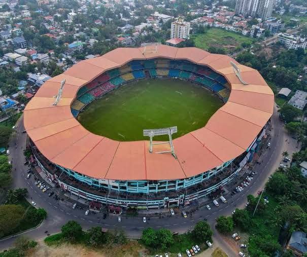
The Jawaharlal Nehru International Stadium, also known as Kaloor Stadium, is a multi-purpose stadium in Kochi, Kerala, India. The stadium has a capacity of 80,000 spectators but is reduced to 41,000 for Indian Super League matches due to various security reasons. It is the home ground of the Indian Super League Club Kerala Blasters FC. The stadium is widely touted to have hosted one of the loudest audiences for association football matches in the world.
The stadium has played host to a number of international cricket and football matches but after 2014 it didn't hold any cricket match due to ISL. The extensive grounds of the stadium serve as venue for important exhibitions, cinema events and political rallies in the city. The most innovative aspect of the stadium is its unique lighting towers of 2 kW Floodlights which when switched on fully can provide lighting levels for HD telecast. The Structure of the tower is itself one of a kind in India. Greater Cochin Development Authority leased out the Jawaharlal Nehru International stadium at Kaloor to the Kerala Cricket Association (KCA) for a period of 30 years.
━━━━━━━━━━━━━
🏝 @ | @ 🥥
Читать полностью…
Kerala
28 апреля 2023 07:11
Nedumangad is a town and municipality in Thiruvananthapuram metropolitan area of Thiruvananthapuram district in the Indian state of Kerala, and is the headquarters of Nedumangad tehsil and Nedumangad Revenue Division (RDO). It is a suburb of the extended metropolitan region of Thiruvananthapuram city. It is located around 16 km to the north-east of Thiruvananthapuram city on the Thiruvananthapuram – Shenkottah (State Highway 2). It is an important commercial center in the district. It is a growing commercial and educational hub and all important government institutions are situated in the town. Nedumangadu Market is important in South Kerala.
━━━━━━━━━━━━━
🏝 @ | @ 🥥
Читать полностью…
Kerala
25 апреля 2023 03:56
The Anamala or Anaimalai, also known as the Elephant Mountains, are a range of mountains in the southern Western Ghats of central Kerala (Idukki district, Ernakulam district, Palakkad district, Thrissur district) and span the border of western Tamil Nadu (Coimbatore district and Tiruppur district) in Southern India. The name anamala is derived from the Malayalam word aana and the Tamil word aanai, meaning elephant, or from tribal languages. Mala or Malai means 'hill', and thus 'Elephant hill.
━━━━━━━━━━━━━
🏝 @ | @ 🥥
Читать полностью…
Kerala
23 апреля 2023 05:19
Palakkad Gap or Palghat Gap is a low mountain pass in the Western Ghats between Coimbatore in Tamil Nadu and Palakkad in Kerala. It has an average elevation of 140 metres (460 ft) with a width of 24–30 kilometres (15–19 mi). The pass is located between the Nilgiri Hills to the north and Anaimalai Hills to the south.
There are various theories about the origin of Palakkad gap. One among them is that it is caused by the landslide due to rivers flowing in opposite directions. The Bharathappuzha river (River Ponnani) originates in the Palakkad Gap from rivulets and tributaries feeding from steep escarpment slopes along the flanks of the Ghats. Another theory suggests that the gap may be created by an asteroid strike around 800 million to 550 million years ago.
The Palakkad gap has played a major role in enabling human migration into Kerala from parts of Tamil Nadu. From 300 B.C. to 13th century, it also helped the Cheras rule the entire Kerala and the Kongu Nadu as one geographical unit from Karur in Western Tamil Nadu. Tamil Brahmins migrated to Palakkad from Central Tamil Nadu via the Palakkad gap from the 15th century to 18th century.
━━━━━━━━━━━━━
🏝 @ | @ 🥥
Читать полностью…
Kerala
21 апреля 2023 07:05
Ottapalam, (also spelled Ottappalam) is a town, taluk and municipality in the Palakkad District, Kerala, India. It is the administrative headquarters of the Ottapalam taluk. Ottapalam is located about 36 km from district headquarters Palakkad. Ottapalam is located along the banks of Bharathapuzha, second longest river of the state.
It is one of the major commercial centres in the district. Ottapalam was raised as a municipality in 1934, making it one of the municipalities that were formed before Indian independence and third oldest municipality in the district after Palakkad and Chittur-Thathamangalam. It is one of the major filming locations in Kerala.
━━━━━━━━━━━━━
🏝 @ | @ 🥥
Читать полностью…
Kerala
19 апреля 2023 06:35
Fort Kochi, Fort Cochin in English, Cochim de Baixo ("Lower Kochi") in Cochin Portuguese creole, is a neighbourhood of Cochin (Kochi) city in Kerala, India. Fort Kochi takes its name from the Fort Manuel of Cochin, the first European fort on Indian soil, controlled by the Portuguese East Indies. This is part of a handful of water-bound islands and islets toward the south-west of the mainland Kochi, and collectively known as Old Cochin or West Cochin. Adjacent to this is the locality of Mattancherry. In 1967, these three municipalities along with a few adjoining areas, were amalgamated to form the Kochi Municipal Corporation.
━━━━━━━━━━━━━
🏝 @ | @ 🥥
Читать полностью…
Kerala
17 апреля 2023 06:44
Beypore or Beypur (formerly Beypoor) is an ancient port town and a locality town in Kozhikode district in the state of Kerala, India. It is located opposite to Chaliyam, the estuary where the river Chaliyar empties into Arabian Sea. Beypore is part of Kozhikode Municipal Corporation. The place was formerly known as Vaypura / Vadaparappanad and also as Beydary. Tippu Sultan, ruler of Mysore, named the town "Sultan Pattanam". There is a marina and a beach while Beypore port is one of the oldest ports in Kerala, which historically traded with the Middle East. Beypore is noted for building wooden ships, known as dhows or urus in the Malayalam language. These ships were usually bought by Arab merchants for trading and fishing but are now used as tourist ships. According to Captain Iwata, founder member of the Association of Sumerian ships in Japan, Sumerian ships might have been built in Beypore. There is evidence to prove that Beypore had direct trade links with Mesopotamia and was a prominent link on the maritime silk route. The first railway line of Kerala was laid in 1861 from Tirur to Beypore (Chaliyam) passing through Tanur, Parappanangadi, Vallikkunnu, and Kadalundi.
━━━━━━━━━━━━━
🏝 @ | @ 🥥
Читать полностью…
Kerala
15 апреля 2023 07:10
Kadalundi River (Kadalundipuzha) is one of the four major rivers flowing through Malappuram district in the Indian state of Kerala. The other three are the Chaliyar, the Bharathappuzha and the Tirur River. This rain-fed river is 130 kilometres (81 mi) long and is one of the most important rivers in the district. Kadalundi River is also the sixth longest River in Kerala. Kadalundi River passes through [Karuvarakundu, Tuvvur, Pandikkad, Manjeri, Malappuram, Panakkad, Parappur, Vengara, Tirurangadi, Parappanangadi, Vallikkunnu, and empties itself into Arabian sea at Kadalundi Nagaram in Vallikkunnu on the northwestern border of the district. It is formed by the confluence of the Olippuzha River and the Veliyar River. The Kadalundi originates from the Western Ghats at the western border of the Silent Valley and flows through the district of Malappuram. It has two main tributaries namely Olipuzha and Veliyar. Olipuzha and Veliyar merge together to become Kadalundi River near Melattur. Kadalundi River traverses through the historical regions of Eranad and Valluvanad. The Kadalundi River drains an area of 1274 km² and has a length of 120 km. The ancient port of Tyndis, which was the second-largest trading port of Chera dynasty, only after to Muziris, is identified with the mouth of this river at Vallikunnu. The Kadalundi Bird Sanctuary spreads over a cluster of islands where the Kadalundipuzha River flows into the Arabian Sea. There are over a hundred species of native birds and around 60 species of migratory birds in large numbers annually.
━━━━━━━━━━━━━
🏝 @ | @ 🥥
Читать полностью…
Kerala
13 апреля 2023 09:32
The Malabar Coast is the southwestern coast of the Indian subcontinent, generally referring to the coastline of Kerala. Geographically, it comprises the wettest regions of South India. The term sometimes is used to refer to the entire Indian coast from the western coast of Konkan to the tip of India at Kanyakumari.
Kuttanad, which is the point of least elevation in India, lies on the Malabar Coast. Kuttanad, also known as The Rice Bowl of Kerala, has the lowest altitude in India, and is one of the few places in the world where cultivation takes place below sea level.
The region parallel to the Malabar Coast gently slopes from the eastern highland of Western Ghats ranges to the western coastal lowland. The moisture-laden winds of the Southwest monsoon, on reaching the southernmost point of the Indian Peninsula, because of its topography, divides into two branches; the "Arabian Sea Branch" and the "Bay of Bengal Branch". The "Arabian Sea Branch" of the Southwest monsoon first hits the Western Ghats, making Kerala the first state in India to receive rain from the Southwest monsoon. The Malabar Coast is a source of Biodiversity in India.
━━━━━━━━━━━━━
🏝 @ | @ 🥥
Читать полностью…
Kerala
12 апреля 2023 01:34
Omassery is a town in Kozhikode district, Kerala, India and it is a junction between Thiruvambady, Thamarassery, Mukkam, Koduvally, Kodenchery and Kattangal. Omassery is located 29 kilometers southeast of Kozhikode in the eastern part of Kerala; better known as Malabar (Northern Kerala). Omassery is a fast developing place and is well connected to the other parts of the state. Besides that, it is known as the gateway to the hill ranges of Western Ghats in Malabar.
━━━━━━━━━━━━━
🏝 @ | @ 🥥
Читать полностью…
Kerala
10 апреля 2023 08:57
Aripara Falls is a tourist spot in Anakkampoyil near Thiruvambady Town in Kozhikode district, Kerala. It is located on the Thiruvambady - Anakkampoyil route, 15 km from Thiruvambadi. The waterfall is a tributary of Iruvanjippuzha. There is a proposal for implementing a hydro power project on the Arippara waterfall.
━━━━━━━━━━━━━
🏝 @ | @ 🥥
Читать полностью…
Kerala
08 апреля 2023 07:40
Ottamthullal is a traditional form of dance-drama from Kerala, India. It was created by Kunchan Nambiar in the 18th century and combines elements of dance, music, and theatre. Ottamthullal performances are known for their comic and satirical themes, with the performer often using humor to comment on social issues or political events. The dance is performed solo or in a group, with the performer wearing a colorful costume and using exaggerated facial expressions and gestures to convey the story. Ottamthullal continues to be a popular form of entertainment in Kerala today.
━━━━━━━━━━━━━
🏝 @ | @ 🥥
Читать полностью…
Kerala
06 апреля 2023 06:42
Kathakali is a classical dance-drama form that originated in Kerala, India. It is known for its highly stylized and intricate makeup, costumes, and movements, which combine elements of dance, music, and drama. The dance form often depicts stories from Hindu mythology and epics, and the performers use elaborate hand gestures, facial expressions, and body movements to convey different emotions and moods. Kathakali is characterized by its powerful and intense performances and has gained popularity worldwide as one of the most impressive and captivating forms of Indian classical dance.
━━━━━━━━━━━━━
🏝 @ | @ 🥥
Читать полностью…
Kerala
04 апреля 2023 07:00
Kalaripayattu is a traditional martial art form that originated in Kerala, India over 3000 years ago. It is a holistic combat training system that includes strikes, kicks, grappling, and weaponry, as well as a system of yoga and meditation to enhance flexibility, agility, and strength. Kalaripayattu is known for its fluid and graceful movements, which are often compared to those of animals. It is still practiced in Kerala and has gained popularity around the world in recent years, with many enthusiasts considering it to be a form of self-defense, physical fitness, and spiritual practice.
━━━━━━━━━━━━━
🏝 @ | @ 🥥
Читать полностью…
Willingdon Island is the largest artificial island in India, which forms part of the city of Kochi, in the state of Kerala. Much of the present Willingdon Island was claimed from the Lake of Kochi, filling in dredged soil around a previously existing, but tiny, natural island. Willingdon Island is significant as the home for the Port of Kochi as well as the Kochi Naval Base, the Southern Naval Command of the Indian Navy, Plant Quarantine station, Custom House Cochin and Central Institute of Fisheries Technology, a constituent unit of Indian Council of Agricultural Research.
The island is also home for other establishments associated with the port, namely, the Office of the Cochin Port Trust (that controls the Port of Kochi), the Customs Office, the Mercantile Marine Department and more than two dozen export-import offices, warehouses, a few hotels and business centers. The Cochin Port Maritime Heritage Museum is located on the island.
━━━━━━━━━━━━━
🏝 @ | @ 🥥
Читать полностью…
Kerala
29 апреля 2023 06:45
Attingal is a municipality in Thiruvananthapuram metropolitan area in Thiruvananthapuram district of Kerala state, India. It was the location of the Attingal kingdom, under Travancore. It is the headquarters of Chirayinkeezhu Taluk, and the important government institutions of the taluk such as the Taluk office, court complex, office of the deputy superintendent of Police, civil station, and treasuries are situated in Attingal. It is one of the oldest municipalities of Kerala which was constituted prior to its independence in 1924. In 1914 itself Attingal Town Improvement Authority (TIA) was formed which was the term used before the municipality regulation act of 1922. Attingal Town is located 25 kilometres (16 mi) north of Thiruvananthapuram. Attingal is the 3rd densely populated municipality in the district.
━━━━━━━━━━━━━
🏝 @ | @ 🥥
Читать полностью…
Kerala
27 апреля 2023 06:00
The stadium at The Sports Hub, Trivandrum is officially named Greenfield International Stadium. It was known as Trivandrum International Stadium. The stadium is a multi-purpose stadium in Kerala, used mainly for cricket. The stadium is located at Kariavattom in Thiruvananthapuram city, Kerala, India. It was built on 36 acres of land leased by the Kerala University for ₹94 lakh (US$146,527.23) per year for a period of 15 years. It is India's first DBOT (design, build, operate and transfer) model outdoor stadium. The Greenfield Stadium became India's 50th international cricket venue on 7 November 2017 when it hosted a T20I against New Zealand. On 1 November 2018, the venue hosted its first ODI. The Greenfield International Stadium is the main venue for the Kerala cricket team.
━━━━━━━━━━━━━
🏝 @ | @ 🥥
Читать полностью…
Kerala
24 апреля 2023 05:53
Palakkad railway division (formerly Olavakkod railway division) is one of the six administrative divisions of the Southern Railway zone of Indian Railways. It is headquartered in the city of Palakkad, Kerala. It is the smallest railway division in the Southern Railway. It was formed by dissolving the Podanur division. Managing 588 route kilometers of track in the states of Kerala, Tamil Nadu, Karnataka and Mahé (in the Union Territory of Puducherry), it is one of the oldest railway divisions in India and had a route connectivity of nearly 1,247 km before the formation of current Thiruvananthapuram and Salem divisions. Major stations under the railway division are Palakkad Junction, Shoranur Junction, Kuttippuram, Tirur, Kozhikode, Vatakara, Thalassery, Kannur, Payyanur, Kanhangad, Kasaragod, Mangalore Central, Mangalore Junction and Pollachi Junction. The terminal facility of Palakkad division is situated in Shoranur Junction & Mangalore Central of Karnataka state.
━━━━━━━━━━━━━
🏝 @ | @ 🥥
Читать полностью…
Kerala
22 апреля 2023 09:35
Bharathappuzha ("River of Bhārata"), also known as the Nila or Ponnani River, is a river in India in the state of Kerala. With a length of 209 km, it is the second longest river that flows through Kerala after the Periyar. It flows through Palakkad Gap, which is also the largest opening in the Kerala portion of Western Ghats. Nila has groomed the culture and life of South Malabar part of Kerala. It is also referred to as "Peraar" in ancient scripts and documents. River Bharathapuzha is an interstate river and lifeline water source for a population residing in four administrative districts, namely Malappuram and Palakkad districts, and parts of Palakkad-Thrissur district border of Kerala and Coimbatore, and Tiruppur of Tamil Nadu. The fertile Thrissur-Ponnani Kole Wetlands lie on its bank.
━━━━━━━━━━━━━
🏝 @ | @ 🥥
Читать полностью…
Kerala
20 апреля 2023 02:52
Eranad also known as Ernad refers to the erstwhile province in the midland area of Malabar, consisting of Malappuram and nearby regions such as Anakkayam, Manjeri, Kondotty, Nilambur, etc. Currently Eranad Taluk is a Taluk in Malappuram district. Eranad was ruled by a Samanthan Nair clan known as Eradis, similar to the Vellodis of neighbouring Valluvanad and Nedungadis of Nedunganad. The rulers of Eranad were known by the title Eralppad/Eradi. They also used the title Thirumulpad.
━━━━━━━━━━━━━
🏝 @ | @ 🥥
Читать полностью…
Kerala
18 апреля 2023 06:47
Chaliyam is a village situated at the estuary of Chaliyar (River Beypore) in Kozhikode district of Kerala, India. Chaliyam forms an island, bounded by the Chaliyar in the north, and River Kadalundi in the south, and the Conolly Canal in the east. It is located just opposite Beypore port. Chaliyam (Beypore Railway Station) was the former terminus of the South-West Line of the Madras Railway. Chaliyam is also famous for the Guinness World Records holder Muhammed Adil, a P.M who covered around seven km in the Chaliyar River with his hand and legs tied with ropes.
━━━━━━━━━━━━━
🏝 @ | @ 🥥
Читать полностью…
Kerala
16 апреля 2023 06:18
Vallikkunnu is a village in Tirurangadi Taluk of Malappuram district in the state of Kerala, India with an area of 25 km². It is located 5 km north of Parappanangadi town and comes under the jurisdiction of Parappanangadi Police Station and Parappanangadi Judicial First Class Magistrate Court. Its latitude and longitude are 11'07" N and 7'51"E respectively. Vallikkunnu was awarded the best panchayath of Kerala in 1997. Vallikunnu is situated on Tirur-Kadalundi Road. Vallikkunnu is also a part of the Oldest Railway Line of Kerala laid in 1861 from Tirur to Chaliyam via Tanur, Parappanangadi, Vallikkunnu, and Kadalundi.
━━━━━━━━━━━━━
🏝 @ | @ 🥥
Читать полностью…
Kerala
14 апреля 2023 06:19
Kadalundi is a village in Kozhikode district, Kerala, India. It is a coastal village close to the Arabian Sea. Kadalundi is famous for its bird sanctuary, which is home to various migratory birds during certain seasons and has been recently declared as a bio-reserve. The Kadalundi-Vallikkunnu community reserve is the first community reserve in Kerala. The Kadalundi River and the Chaliyar river, two of the longest rivers of Kerala, merge with the Arabian Sea at Kadalundi. The first railway line in Kerala was laid in 1861 from Tirur to Chaliyam through Tanur, Parappanangadi, Vallikkunnu, and Kadalundi.
━━━━━━━━━━━━━
🏝 @ | @ 🥥
Читать полностью…
Kerala
12 апреля 2023 16:03
🎈Is your english not as good as you wish it should be?
🎈Do you want to practice english but can't due to various circumstances?
🎈 Do you wish to learn english in a fun and easy manner?
📫 To solve the above issues join us and start learning
/channel/+RKTKIAYA-RJhYjdl
▶️ Join @
🚨 Rules for chatting 🚨
Читать полностью…
Kerala
11 апреля 2023 06:53
Mukkam is a major municipality town in Kozhikode, state of Kerala, India. Mukkam is one of the major regional suburbs of the Kozhikode district. Mukkam is located about 27 km east of Calicut city on the bank of river Iruvanjippuzha, one of the major tributaries of river Chaliyar .Mukkam is also well known for its secularistic features. The urban region of Mukkam is spread across Mukkam Municipality and the North Karassery region of Karassery Grama Panchayath. The town begins from North Karassery junction region and runs till Agasthianmuzhi Junction region.
━━━━━━━━━━━━━
🏝 @ | @ 🥥
Читать полностью…
Kerala
09 апреля 2023 07:18
Kerala Kalamandalam, deemed to be University of Art and Culture by the Government of India, is a major center for learning Indian performing arts, especially those that developed in the Southern states of India, with the special emphasis on Kerala. It is situated in the small town of Cheruthuruthi in Thrissur, Thrissur District on the banks of the Bharathapuzha river.
━━━━━━━━━━━━━
🏝 @ | @ 🥥
Читать полностью…
Kerala
07 апреля 2023 07:05
Mural painting is a traditional art form that originated in Kerala, India. It involves the use of bright colors and intricate designs to depict various scenes from Hindu mythology and history on the walls of temples, palaces, and other public buildings. The paintings often include images of gods, goddesses, and mythological creatures, and are meant to convey moral and spiritual messages. Mural painting is characterized by its vibrant colors, attention to detail, and unique style, which has made it popular among art enthusiasts and collectors around the world.
━━━━━━━━━━━━━
🏝 @ | @ 🥥
Читать полностью…
Kerala
05 апреля 2023 08:42
Kunjunni Mash (1906-1977) was a prominent Malayalam poet from Kerala, India. He is known for his simple and lucid style of writing, which made his poetry accessible to the masses. Kunjunni Mash wrote about the beauty of nature, the struggles of the common man, and the joys and sorrows of everyday life. His works have been widely translated and continue to be popular among readers of all ages. In recognition of his contributions to Malayalam literature, he was awarded the Sahitya Akademi Award in 1968.
━━━━━━━━━━━━━
🏝 @ | @ 🥥
Читать полностью…
Kerala
03 апреля 2023 06:56
Mohiniyattam is a classical dance form that originated in Kerala, India. It is traditionally performed by women and is characterized by its graceful movements, flowing costumes, and subtle expressions. The dance form incorporates elements of music, rhythm, and storytelling to convey various themes and emotions. Mohiniyattam is known for its delicate footwork, hand gestures, and eye movements, which are meant to convey different emotions and moods. The dance form has gained popularity around the world and is considered to be one of the most beautiful and graceful forms of Indian classical dance.
━━━━━━━━━━━━━
🏝 @ | @ 🥥
Читать полностью…


 10366
10366